I recently bought a new big-size camera, bucking the trend of simply using one's iPhone for photographs. That's not to say I don't use my iPhone; it is my main picture taking device. But I wanted a camera that could capture native retina iMac images (at least 5120x2880), and the iPhone can't do that.
After much looking and sweating over the costs, I chose a Nikon D5500, mainly because I already had a Nikon and didn't really want to replace all my lenses. While this is an excellent camera, it was a bit of a budget compromise—it didn't have all the features I really wanted. In particular, it lacks a built-in GPS to geocode all the pictures I take.
As a workaround, I decided to buy a GPS data logger, which is just a small GPS receiver that records GPS coordinates at some interval. Toss the logger in your pocket (make sure it's on and receiving the GPS signals first!), then go take pictures as you normally do. When you return, you can use an app like HoudahGeo to sync the recorded GPS track with the timestamps on each photo. (I'll have more to say about this whole sync process in a future post.) Presto, instant geocoded images!
Yes, you can do this with any number of iPhone apps, too. But the logger frees me from taking the iPhone if I don't want to, and remembering to start (and stop—GPS logging can really suck up the iPhone's battery) the app before taking pictures. Typical loggers will have at least 20 hours of battery life, meaning you can just turn it on and go, and not think about it again.
I've had a GPS data logger before—a Qstarz BT-Q1300ST—but its interface was so cumbersome (one button, no display!) that I rarely used it, because I couldn't ever figure out if it was working or not. I wanted to find a reasonably inexpensive logger with some form of visible interface.
So many choices
A quick search on Amazon will turn up dozens of matches for GPS data loggers, at price points ranging from really cheap to really expensive. How do you know what you need, and how much you should spend?
Only you can answer that question, but I knew I wanted a logger with a display. I also didn't care about Bluetooth connectivity, because I wasn't intending on pairing the logger with anything. I just wanted it to record tracks, be usable with the Mac (not all are), and be very small and light.
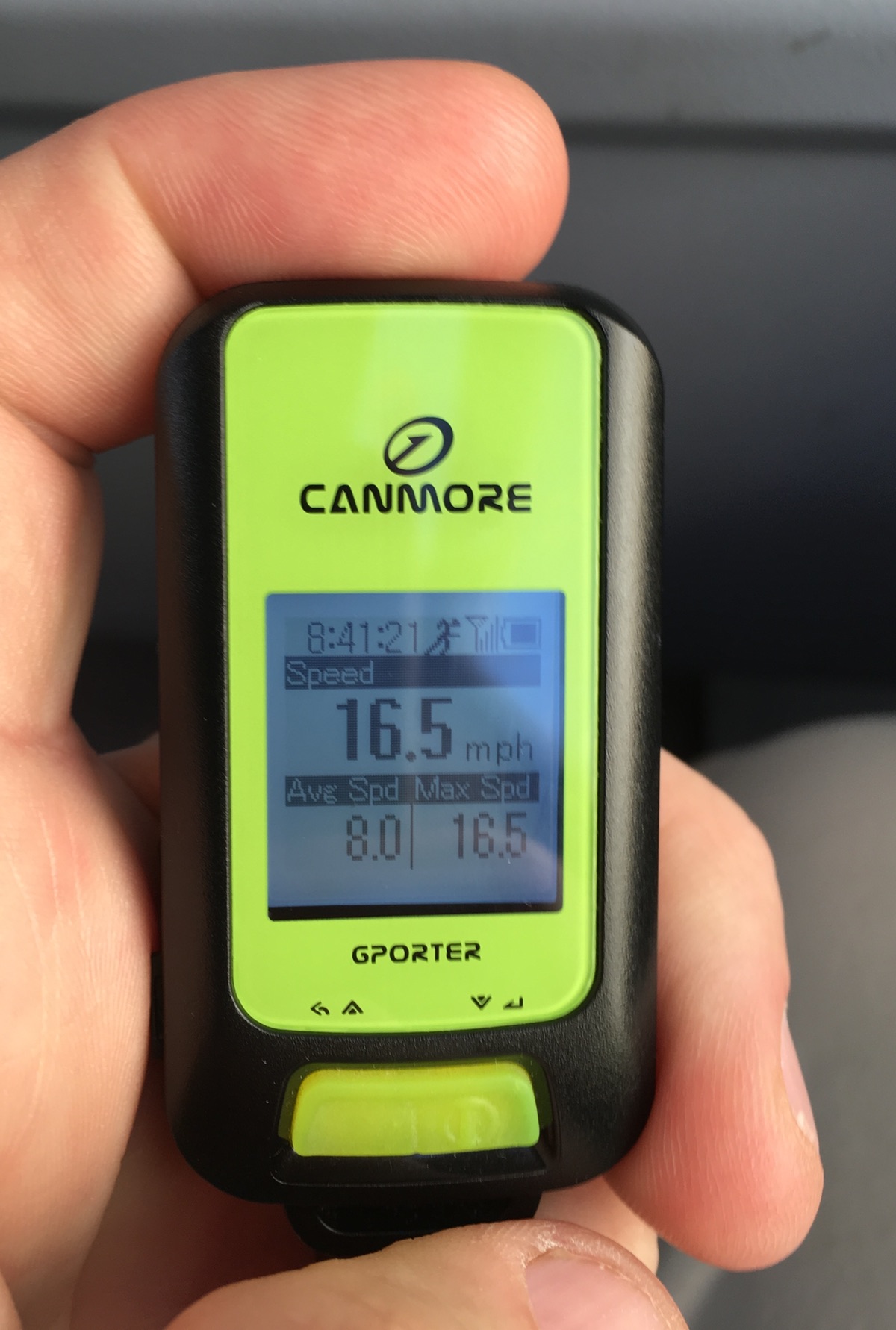 After some digging, I decided to try the Canmore GP-102+ data logger.
It was relatively inexpensive (I paid $53), and though thicker than my old Qstarz, it weighs nearly the same, and is actually a bit narrower (with the same height). The device mounts as a USB drive, making it easy to grab its data files, which it writes in .fit (Garmin activity file) format. Those .fit files can be read directly by HoudahGeo, or you can convert them to Google Earth path files using GPSBabelFE.
I took the Canmore with me on a recent trip to Germany and the UK, and used it not just for geocoding, but during runs, hikes, train rides…pretty much any time we went out, I slipped it in my pocket. The results were great: I was able to easily geocode my photos, and the ability to see the paths in Google Earth was geeky-cool. Here's a hike we took in the Black Forest area of Germany, for instance:
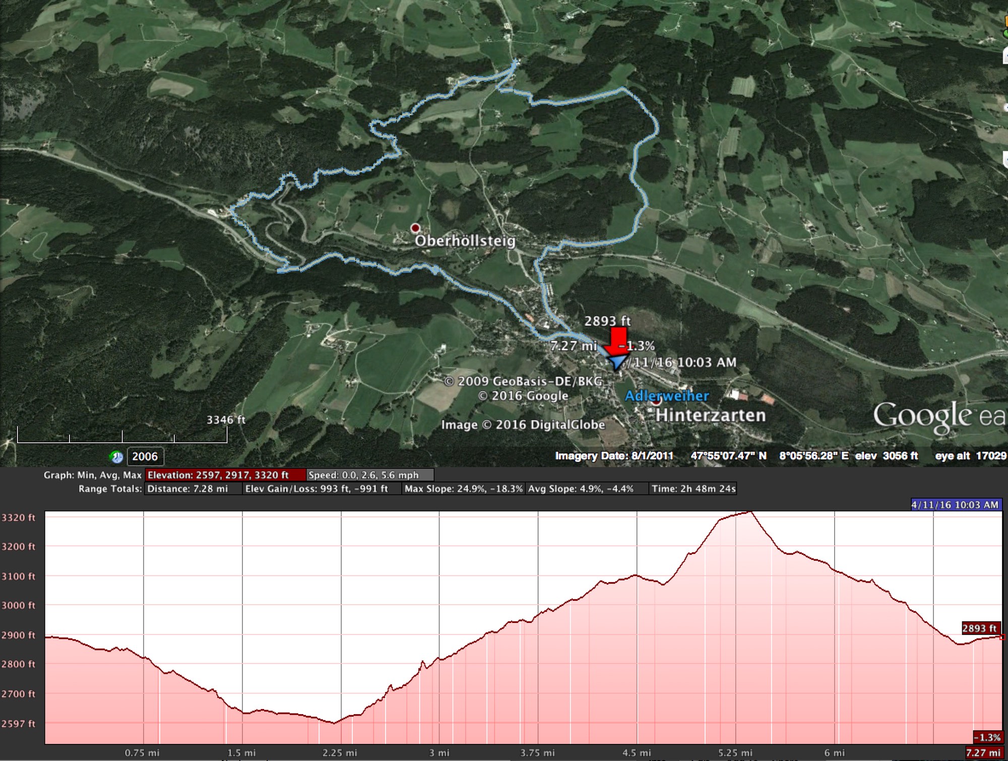
I never took the GP-102+ out of my pocket, and as seen by the path track, it was able to get a signal sufficient for plotting our hike.
In use
The Canmore has a very basic screen, along with two buttons. Each button supports short and long taps; short taps are used for navigating between icons, and long taps for selecting a task or canceling. After powering on the device, you select an activity to start logging—you can pick from running, cycling, walking, hiking, and driving. The manual is unclear, but my guess is that the different activities have different GPS sample rates—driving would need quicker updates than would walking.
The screen is tiny, and can be hard to read in direct sunlight, but it's still miles better than no screen at all. And having two buttons makes navigating much simpler, and the functions are logical. Unlike with my Qstarz, I never had any question as to whether the device was tracking or not.
Once you've started an activity, you need to wait for the GPS signals to lock on before you can really start tracking. Depending on where you are, this may take a few minutes. Clear outdoor sky with no obstructions works best; indoors, and you may never get a sync. The Canmore display shows you exactly how it's doing during the satellite lock process:

On the left is the GPS lock display, as seen just after power on. On the right, the unit has found nine satellites, and locked on to signals from five of them. The height of the bars indicates the relative strength of the signals—they're low here because I moved inside to take the photo.
Once locked, the Canmore did an admirable job of holding onto the satellite signal. If it lost it, it was also quite quick to reacquire. For instance, we were on a train to the Black Forest in Germany, and there are several tunnels on the route. The Canmore would lose the signal in the tunnel, but then reacquire it very quickly once we exited:

The straight line entering mid-upper-frame is from when the train was within the tunnel (lower left). But within a few seconds of exiting the tunnel, the Canmore re-locked the satellites, and was back to tracking the train accurately again.
When you're done with your activity, a long press on the right button brings up a menu with a "Stop log" option. Once stopped, you can transfer the .fit files directly to your Mac by connecting the Canmore via a UPS cable. If all you want is geotagging, that's all you need to do—you then sync the data files to your camera's clock using HoudahGeo (or similar), and the program does the rest.
While plugged in, the battery would recharge—and it's pretty quick about it, too. But if I didn't get to recharge on a given day, I didn't worry too much, as there's enough power there to get through a couple days of recording.
I also used GPSBabelFE to convert the .fit files into Google Earth's .kml format, so I could put the paths in Google Earth. As seen in the hiking map above, this worked quite well; if you use the Show Elevation Profile, you'll also get the graph showing elevation (and speed, which I had disabled for the screenshot) below the track.
Wrapping it all up
In short, for just over $50, the Canmore was well worth its cost. It let me easily geotag nearly all my trip photos (excluding those taken from airplanes!), and worked very well as a trip recorder so I could see our various tours again in Google Earth. The screen eases interaction with the device, and file transfer was quick and easy. If you're in the market for a GPS logger, the Canmore G-PORTER GP-102+ is worth a look (even if it does have a ridiculous name).
Thanks for the interesting and thorough review. I carry around a Garmin GPS 62ST for data logging and I have a Canon GPS that fits on the hot shoe of my camera (I like it easy). But a cheaper and easier solution may be nicer than an expensive GPS so I may look at getting a logger.
Also, I log my plane flights when I can. I haven't gotten kicked off yet. Some airlines don't allow GPSs explicitly but most don't care. And since it's a receiver and not a transmitter I don't see how it could affect avionics. I sometimes use a remote antenna with a suction cup on the window to get a better signal.
The long flight on Air Canada, they explicitly stated that anything that receives a signal must be disabled. Seems very weird to me, too, and I'm confident that a $50 device in my pocket 100' from the cockpit can't possibly interfere with the aviation gear.
-rob.
Thank you for this post! I have also been using a QStarz BT1000 for the last few years, specifically for data logging/geocoding photos and loved that 1) it got great reception and 2) would run for at least 2 days on a charge! But I too have gotten fatigued with the poor MacOS integration and have been wondering if there was something comparable with a simple USB interface.
You didn’t mention what kind app is available for controlling the data logging process - I appreciated that the otherwise flaky BT747 Java app that I needed to talk to the QStarz had very detailed control over logging parameters, GPS-A database loading, etc. I hope the Canmore had something to control it beyond “power-and-go” functionality.
(BTW, when I’ve forgotten to turn off the QStarz it has successfully tracked trans-Pacific flights from an aisle seat. How could the crew detect a GPS receiver and how could it interfere with navigation anyway?)
Steve: I'm afraid I'm not much help here - I've only used the device's built-in tools which let you specify what type of activity, which I assume changes the recording rate. I'm not aware of anything like the BT747 app for the Canmore. I just needed basic GPS logging, and it seemed to do that part just fine.
As for detecting, you're probably right (and interfering, definitely right).
-rob.
Just got a GP-102+, looking for tips.
Which Mode so you typically use for logging for photos?
Jogging, Cycling, Walking?, Hiking?, Driving? I'm not sure what's the point of each?
thanks, Bobby
I believe the mode has to do with the sample rate (and hence, battery life). I've found no documentation on this, but it would make sense. If you're going faster (driving), it needs to get a GPS reading more often to provide accurate tracking.
So for shooting photos, I used walking. Seems to work just fine.
-rob.
Thanks Rob, that seems like a logic description. In you examples you mentioned using it on a train, a still having good accuracy, was that in "walking" mode?
I'm a bit surprised by how light the documentation is for basic features.
Thanks Again!
My husband uses one of these for windsurfing, however it has locked up on him and despite trying everything conceivable he cannot get it working again. The display shows pic of charging plug......and ideas??
It's a display of USB icon apparently..
Sorry, no ideas - I've had no issues with mine at all. Maybe it got wet?
-rob.
Hi,
I have a Canmore GPS- 102 but it does not work properly. Apparently, it's not possible communication between device and computer to transfer data using USB port. Tried different computers but they cannot find the GPS drive-
Then i would like to ask for help for how I can get access to this device, to fix the problem or, at least to get information to fix the problem.
Thank you very much.
Robson
I don't think I can help - I plug mine in, and it shows up like any other USB storage device. Sorry i can't be of more assistance.
-rob.
Thank you for the detailed article! It is exactly what I was looking for. I was trying to figure out ways to geotag photos I will be taking on my Hawaii trip using a sony a6000 camera. After looking through smartphone apps and smartwatches which either is an ideal solution, I came across the Canmore GPS-102+ on Amazon. What was your experience with its storage space? I'm on the trip for over 2 weeks and do not plan to bring a laptop with me. Did you have to export your files frequently? Or does the device let you know how much storage space it has? I'm hoping it can at least store a good month of walking around I can just export all the files when I'm back home from the trip.
Thank you very much,
Shirley
It's got flash memory for "up to 300,000 data points." How often a data point is stored depends on the mode: If you tell it you're walking it will record fewer times per minute than if you tell it you're in a car.
With 300,000 points, you should be fine: Assume it records every six seconds while walking, that'd be 10 data points a minute, or 30,000 minutes of recording. That's 500 hours of walking, or a couple months' worth of eight hour walking days. So I think it'll be fine. As far as I know, there's no way to see how much storage space is left. Looking at the manual, it seems you can set the log rate, in either time (1, 5, 10 seconds) or distance (5, 200, 500 meters).
I don't think it can tell you how much storage space is left, though you can browse what it has logged. And you'll definitely need to bring some way to charge it: Using the GPS, you'll get about 15-20 hours of usage out of it before it needs a charge.
-rob.
Thank you for your article!
Is it possible to get real time position by the usb link ? not only the past tracking in a data-logger file.
I'm looking for a cheap gps with a (small) screen, a compass (when I don't move) and a real-time link to a laptop in order to display maps.
Have a nice day !
I have a GPORTER for almost a year now and I is great and a real important tool in K9 Search and Rescue. It is attached to my dogs harness, great when we do off lead air scenting and he is all over the place, so to speak. Just recently it is not working properly, I t may do about 100 to 200 meters and then stops. What is recorded is somewhat all over the place. This is what I have done so far.
1. It is charged.
2. It is on hiking mode.
3. Calibrated.
4. old files deleted.
5. Reset factory settings.
It is still producing the same problem....any ideas?
Cliff:
Sorry, I don't have any idea; you'll probably have to contact them directly.
-rob.
Thanks. I tried but from my end their website in down. I will contact the dealer. Thanks. Would you know of any other unit that small that you would recommend
Yea, looks like they may be goners, bummer. The only other device I had any experience with is the Starz I mentioned in the article.
-rob.
My Canmire dies not log; I can not find the files... in which directory does it file to?
On mine, they're .fit files stored in the path GP-102 > Activities.
regards;
-rob.
Comments are closed.